


According to the Extraordinary Bulletin of Dangerous Weather Phenomena issued today, Tuesday 12 October 2021 by the National Meteorological Service (EMY), a) the rains and thunderstorms that occur today Tuesday (12-10-2021) in many areas of the eastern country and are temporarily strong will gradually be limited to Thrace, the islands of the Eastern Aegean and the Dodecanese and from the evening hours will weaken, b) a new weather system called BALLOS will cause new bad weather in the country from Thursday (14-10 -2021) and from the west – southwest, with main characteristics:
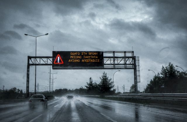
The heavy rains and thunderstorms, which will be accompanied in places by hail and temporarily during the phenomena of strong gusts of wind. The intense phenomena will initially affect the Ionian, the western continents and Macedonia and from noon on Thursday gradually the rest of the country.
On Friday (15-10-2021) bad weather is initially forecast throughout the country, but the intense phenomena from the afternoon hours in the northwest will weaken.
On Saturday (16-10-2021) heavy rains and thunderstorms will affect the eastern country, but gradually the effects will weaken.
Stormy south winds of 7 to 8 Beaufort. In Northern Greece from Thursday night (14-10-2021) north winds will prevail with the same intensity, while on Friday (15-10-2021) the south winds in the Aegean will probably reach 9 beauforts locally.
The noticeable drop in temperature in Northern Greece by 6 to 7 degrees Celsius.
Citizens can be informed daily about the development of extraordinary weather phenomena in the regular weather reports of EMY and on the website of EMY at the electronic address www.emy.gr.
The General Secretariat for Civil Protection (www.civilprotection.gr) of the Ministry of Civil Protection, has informed the competent state services involved, as well as the regions and municipalities of the country, in order to be on increased alert for civil protection, in order to deal immediately the effects of severe weather.
At the same time, the General Secretariat for Civil Protection advises citizens to be especially careful, taking care to take measures to protect themselves from the dangers arising from the occurrence of severe weather phenomena.
In particular, in areas where heavy rainfall, thunderstorms or strong winds are forecast:
Secure items that, if swept away by severe weather, could cause damage or injury.
Make sure that the gutters and drains of the houses are not blocked and are operating normally.
Avoid crossing torrents and streams, on foot or by vehicle, during storms and rainfall, but also for several hours after the end of their event
Avoid field work and activities in the sea and coastal areas during severe weather events (risk of lightning strikes).
Take immediate precautions during a hailstorm. Take refuge in a building or car and do not leave the safe area until they are sure that the storm is over. Hail can also be very dangerous for animals.
Avoid passing under large trees, under hanging signs and generally in areas where light objects (eg pots, broken glass, etc.) can come off and fall to the ground (eg under balconies). .
To faithfully follow the instructions of the locally competent bodies, such as Traffic, etc.
For information and announcements regarding the prevailing situation and the passability of the road network due to the inflow of flood waters in it, the citizens can visit the website of Hellenic Police www.astynomia.gr.
For more information and instructions for self-protection from severe weather conditions, citizens can visit the website of the General Secretariat for Civil Protection at www.civilprotection.gr.