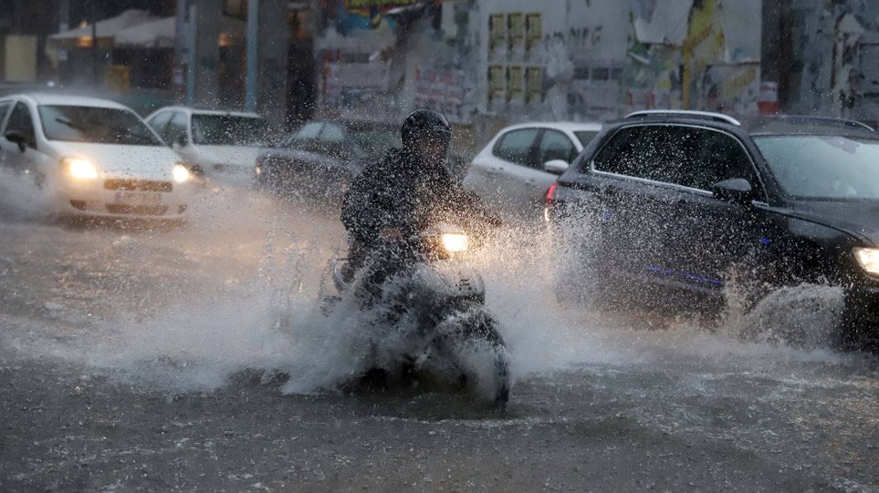


Heavy rain and thunderstorms accompanied by hail and high frequency of lightning will be produced by the Elias system according to the latest updated Emergency Weather Bulletin (9/25).
In more detail:
Today in places strong rains and storms will occur mainly in Thessaly, as well as in western Macedonia, the western parts of central Macedonia and in the prefectures of Fokida, Fthiotida, Evrytania and Viotia of Sterea. For the time being, Epirus, western Mainland and northern Peloponnese are likely to be affected. It is noted that in Thessaly the highest rainfall levels will occur in the prefectures of Karditsa and Trikala as well as in the west and north of the prefecture of Larissa.
Tomorrow, locally heavy rains and storms are predicted in the Ionian, the mainland (except Macedonia and Thrace) and towards the evening hours in the Sporades and northern Evia. The highest levels of rain will be noted: in Thessaly (in the prefectures of Karditsa, Trikala, Magnesia and the southern parts of the prefecture of Larissa), in Sterea (in the prefectures of Fthiotida, Evrytania and Viotia) and in Epirus (in the prefectures of Arta and Preveza).
On Wednesday (27/9) locally heavy rains and storms are predicted in the Ionian, the central and southern mainland (in Thessaly, Sterea Hellas and Peloponnese), the Sporades, Evia, western Crete and possibly the western Cyclades. It should be noted that the highest rainfall levels will occur in the prefectures of Karditsa, Fthiotida, in the eastern parts of the prefecture of Magnesia and in northern Evia.
On Thursday (28/9) locally heavy rains and storms are predicted until noon, in the Sporades, Magnesia, northern Evia, and the northeastern parts of Sterea.
Gradually the phenomena will weaken.
Where heavy rain is expected in the next 48 hours – When will it rain in Attica
Rains and sporadic storms will occur in Western Macedonia from the morning hours of Monday 25/09. According to the forecast data of meteo.gr, during the day the phenomena will spread mainly in the western, central and southern country and from the afternoon they will intensify significantly, accompanied by hailstorms in places.
The areas that will be most affected, receiving the largest volumes of water, will be Thessaly (mainly the prefectures of Trikala and Karditsa), Central Sterea (prefectures of Evrytania, Fokida and Fthiotida) and Northern Peloponnese (mainly the prefectures of Achaia and Corinthia).
On Tuesday 26/09, as the atmospheric disturbance of the upper atmosphere (cold lake) responsible for the bad weather will be in the South Ionian, and combined with surface barometric low unsettled weather will again prevail in Western, Central and Southern Greece. In these areas, rains and storms will occur from time to time, phenomena that will be strong in places.
According to the classification of the rainfall episode (RPI), which is applied by the Meteo unit of the National Observatory of Athens, the rainfall episode for the two days Monday 25/09 and Tuesday 26/09 is classified as Category 3 (Significant).
The forecast map below shows the estimated geographical distribution of cumulative rainfall (in millimeters) until the end of Tuesday 26/09. Deeper shades show the highest precipitation heights.
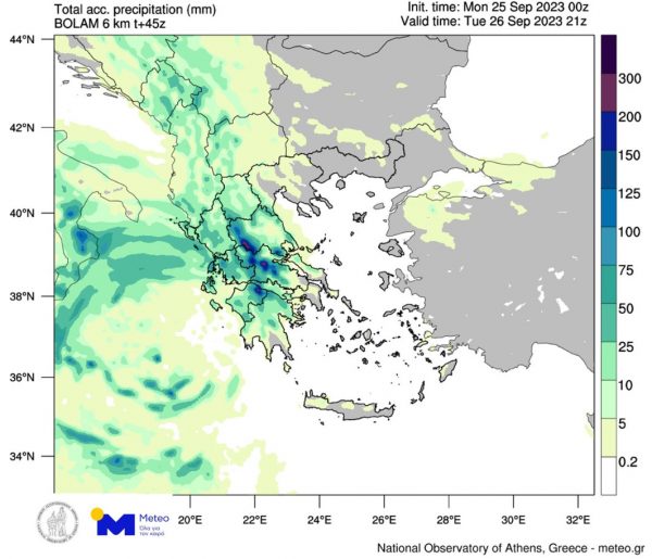
Significant rain amounts are shown in dark shades
Specifically for Thessaly, as shown in the forecast map that focuses on the wider region, the highest rainfall levels (in millimeters) until the end of Tuesday 26/09, are expected in the areas of Pelion and Othrios, as well as in the western parts of the region .
According to the available data, on Wednesday 27/07 the bad weather will continue with more and more intense phenomena (also in Thessaly), while Attica, Crete, the Cyclades, Evia and the Sporades are now expected to be significantly affected.